A Deeper Look

A Deeper Look!
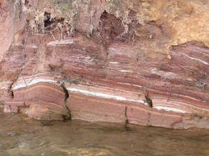
Part of the interface between South Carolina piedmont and southern Blue Ridge Escarpment is enclosed within a little-known tract of land called the Jocassee Gorges. Only a couple of highways penetrate this land, and the best access is from Lake Jocassee, which nestles into the folds of the mountains at 1100’ above sea level. The lake was built in the 1960s, and is used today, for hydroelectric power. A geographic feature known as the Brevard Zone dissects the upper reaches of the lake, through all four of the river regions that provide its water. The fluctuation of the lake level, due to energy usage and maintenance of lake levels further downstream, offers up to thirty feet of washed mountain topography without the overlying skim of top soil and plants. Touring Lake Jocassee, when the water level is 5’ down, or 15’, or 25’, is to peek inside the wild, wonderful puzzle of mountain-building in the southern Appalachian mountain range. This is our place, and if it has ever touched a place deep inside, it’s your place, too. ~K
